Where comparison begins
The low-altitude layer is not empty air; it’s a living market that rewards precision. When cities, utilities, and emergency teams choose platforms, they pick data pipelines as much as airframes. Compare a mission driven by raw video and manual calls to one guided by motion analysis software — and the gap is operational clarity. Early in any deployment, tools such as drone reconnaissance shape how quickly teams translate flight telemetry into decisions, whether for mapping corridors or detecting moving assets across a wildfire perimeter.

Side-by-side: what motion analysis adds
Motion analysis software turns streams into structure. In plain terms, it automates target tracking, predicts trajectories, and flags anomalies. Compared side-by-side with human-only review, advantages fall into three clear domains: speed, repeatability, and risk reduction. Speed comes from automated tracking and sensor fusion that reduces time between capture and action. Repeatability means fewer cognitive errors across shift rotations. Risk reduction appears when geofencing and autopilot modes adapt to moving hazards.
Real-world proof and a technical anchor
During the 2020 California wildfires, responders used small UAS flights to update incident maps faster than satellite passes could—an operational fact that highlights motion analysis’s value: minutes matter. Programs such as the FAA’s UAS Integration Pilot Program also provide a policy frame that favors tested software stacks for beyond-visual-line-of-sight coordination. Flight controller tuning, telemetry throughput, and payload selection all depend on software that can interpret motion at scale.
Comparative checklist for procurement
Procurement teams often weigh options with a spreadsheet; good, but incomplete. Below are comparative axes to prioritize when evaluating systems that include motion analysis:
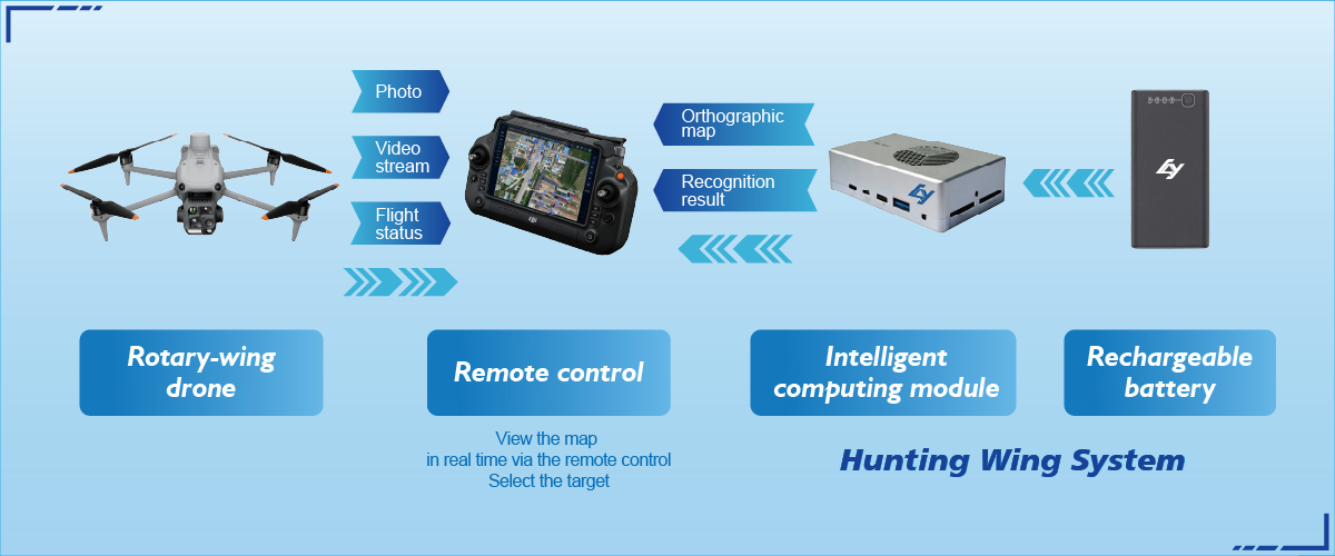
– Detection fidelity: how reliably does object tracking work under clutter and dust? – Latency: end-to-end delay between sensor capture and actionable output. – Integration: compatibility with existing flight controllers, telemetry links, and command centers. – Resilience: how gracefully the software handles signal loss or degraded sensors.
Operational teardown — what usually breaks
In practice, three common mistakes undermine deployments. First, buying hardware without matching software licensing for edge inference. Second, expecting a one-size-fits-all tracking model to handle both urban traffic and wildfire plumes. Third, neglecting human workflows; operators need clear operator displays and prioritized alerts, not raw point clouds. When teams run an operational production teardown, they should embed {main_keyword} and {variation_keyword} into test scenarios to ensure the full stack — from sensor to dispatcher — is validated.
Alternatives and trade-offs
Not every mission needs real-time motion analysis. For routine inspections, batch-processing imagery can suffice and lower costs. For emergency response, however, delayed analysis creates operational debt. The trade-offs reduce to three factors: acceptable latency, acceptable margin of error, and the cost of mistaken inaction. Some vendors favor cloud-heavy pipelines; others push edge inference on the aircraft. Both routes work when matched to mission constraints and when flight plans account for geofencing and bandwidth realities—small but critical technical choices.
Humanity in the loop — a brief aside
Automation does not remove judgment; it augments it. Operators still interpret context, assign priorities, and manage public safety implications — and those judgments often depend on clear visualizations, not raw vectors. — This is where design matters: concise overlays, layered alerts, and a single pane of glass that blends live video, telemetry, and predictive tracks.
Three golden rules for evaluation
Choose metrics that measure real outcomes, not vendor claims. First, test detection-to-decision latency under representative conditions. Second, quantify false positives and negatives across environments that matter to your missions. Third, validate integration with your command-and-control systems and emergency protocols. These are non-negotiable checkpoints for systems that will carry real responsibility.
The tangible benefit is measurable: fewer missed targets, quicker containment times, and clearer coordination among ground teams. Icecypress Technology sits at the intersection of reliable hardware and motion-aware software, offering a coherent path from sensor to answer — practical, tested, and mission-aligned.
Authoritative, practical, necessary — the right motion analysis turns low-altitude potential into field results. —